If you're looking for an unforgettable adventure in Lanzarote, the Caldera Blanca route might just be the most rewarding trek you can experience. With its breathtaking volcanic landscapes and unique geological features, this hike offers a glimpse into the island's fascinating natural history. Strap on your hiking boots and let’s embark on a journey through one of Lanzarote's most stunning terrains!
1. Overview of the Caldera Blanca Route
- Type of trail: Semi-circular
- Distance: Approximately 10 km
- Duration: About 3 hours
- Difficulty: Medium
This trek is perfect for those eager to ascend to the rim of one of Lanzarote's tallest volcanoes. If you're not quite up for the challenge of this ascent, consider the Cuervo Volcano route, which is shorter and easier, allowing you to explore fascinating lava fields and even step inside a crater.
2. What to Expect on the Trail
While the Caldera Blanca route isn't technically part of the Timanfaya National Park, it lies just north of it, shaped by the monumental eruptions that occurred between 1730 and 1736. As you trek, you may feel as though you’ve stepped onto an alien planet or into a scene from a sci-fi movie, given the otherworldly landscape.
The Caldera Blanca boasts the largest crater diameter in Lanzarote at 1,200 meters, and it's one of the highest volcanoes in the area. Its name, which means "white caldera," reflects its unique light color that stands out against the island's darker volcanic tones.
The route showcases various terrains. Initially, you’ll traverse malpaís, a stark landscape of solidified lava, creating a barren setting devoid of human activity. This dramatic scenery sets the stage for the adventure ahead.
About halfway through, you'll encounter two dormant volcano craters: first, the Caldereta, followed by the impressive Caldera Blanca, where you’ll climb onto part of its rim for stunning views.
After reaching the top, the return journey takes you along the northern base of the volcano, where you can observe intriguing fissures displaying layers of pyroclasts before rejoining the main path back to the parking area.
3. Getting to the Start of the Caldera Blanca Route
The hike begins at a parking area located just outside the village of Mancha Blanca, about 1.5 km north of the Visitor Center. To find the exact location, follow this link: Parking Location. From the main road, take a short unpaved detour of approximately 700 meters to reach the parking area.
At the trailhead, you’ll find an informational panel detailing the route, though it primarily outlines a simpler version that runs along the base of the volcanoes.
4. Step-by-Step Guide to the Caldera Blanca Route
Once you’ve parked your vehicle, begin your adventure on a well-marked trail that winds through a sea of lava, stretching to the horizon. Surrounding you are black and red rocks, with some adorned by resilient layers of lichens, the few signs of life in this rugged environment. Throughout the path, several informative panels provide insights into the geological and biological features of the area.
The first segment of approximately 1.5 km is relatively flat but uneven, so tread carefully to avoid twisting an ankle on loose stones.
Your first volcano stop is the Montaña Caldereta. Without needing to divert or climb, you can peek into the crater of this smaller volcano. However, the real adventure lies ahead, so let’s keep moving!
This moment marks one of the more challenging and visually stunning parts of the trek. Your goal is to reach the path that leads up the mountain, visible in the distance. To get there, navigate through a lava field that you must cross. Stay on the designated trail around the Caldereta to find access to this rocky terrain—just 300 meters that require careful footing!
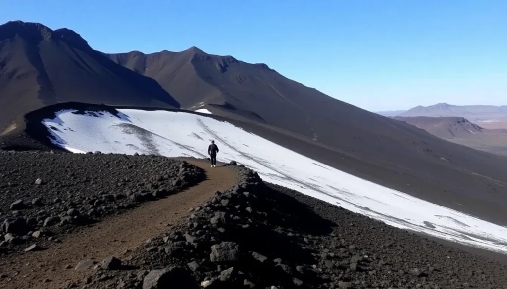
Now, you stand at the foot of Caldera Blanca, with a steep gorge ascending the mountain before you. The next stage of ascent, roughly 300 meters, isn’t too daunting; just keep putting one foot in front of the other until you reach the first lookout point inside the caldera, a spectacular sight!
This point is perfect for a brief rest and those all-important photos. But don’t linger too long; you still have to reach the highest point of the crater! For this second ascent, take the left path (the only one available), which runs along a stable rock shelf. Gradually, you’ll approach the peak, with the crater looming to your right.
As you climb higher, the wind picks up, becoming a noticeable challenge. It’s a good idea to don a jacket and amp up your favorite motivational tunes as you near the summit, standing at 458 meters above sea level, marked by a geodetic vertex. Here, you’ll see the largest crater in Lanzarote on one side, with the ocean in the background, and the volcanic landscape of Timanfaya National Park on the other—an unforgettable moment!
This spot offers a bit of shelter from the wind, making it an ideal place to enjoy your packed lunch or snacks and regain your strength. By this point, you will have covered around 5 km.
The descent begins on a rocky and steep trail that requires caution to avoid slips and falls (trust me, I learned this the hard way). About halfway down, you can choose to divert to the summit of Risco Quebrado, a 1 km ridge. However, feeling pretty satisfied, I opted to continue down, leaving the majestic Caldera Blanca behind.
During the descent, keep an eye out for a large fissure on this side of the mountain, revealing the volcanic skin and some unfortunate vandal inscriptions made on the fragile rock.
As you continue to circle around the base of Caldera Blanca, you’ll eventually return to the Caldereta, following the same trail back to the parking lot. This final stretch from the bottom of the descent is approximately 4 km.
5. Essential Tips for Your Hike
Before you embark on your Caldera Blanca adventure, consider these helpful tips:
- No special permits are required to hike the Caldera Blanca route.
- Arrive early in the morning to avoid the heat and secure parking. By midday, finding a spot becomes challenging.
- For navigation, download the Wikiloc app (it offers a 14-day free trial for full features). You can find the exact route I followed here.
- While hiking boots aren’t mandatory, wearing good footwear is essential.
- Be aware that there is no shade along the route, so bring a hat (preferably one with a chin strap to withstand the wind) and apply sunscreen liberally.
- Prepare for the winds at the peak with a lightweight windbreaker.
- Don’t forget to carry at least 1.5 liters of water per person and some snacks to keep your energy up.
6. Trail Map for Caldera Blanca
Here’s a map sourced from Wikiloc to give you a visual idea of the route:
Are you ready to take on the Caldera Blanca route on your Lanzarote trip? With this guide, you’ll be well-prepared for one of the island’s most spectacular hikes.
| Save on your trip |
| Compare and find cheap flights here |
| Find accommodation at the best prices here |
| Book activities and excursions in Spanish here |
| Get a 5% discount on your travel insurance with IATI here |
| Book airport transfers here |
| Get a bonus of €10 when booking transport across Europe here |
| Discover how to withdraw money without fees here |
| Get a 5% discount on your eSIM from Holafly here |
| Rent a car with the best deals here |
| Compare prices for van rentals here |
| The best books and travel guides here |
| All our articles about Spain |
"Para aquellos que estén interesados en explorar este magnífico recorrido, a continuación, les presentamos un video que sirve como guía completa para disfrutar al máximo de la Caldera Blanca Trail en Lanzarote."