Embarking on the Tongariro Alpine Crossing is more than just a hike; it's an adventure that promises breathtaking landscapes and unforgettable memories. As you prepare for this iconic journey, every detail matters—from your gear to your physical readiness. If you're contemplating this hike, buckle up for an informative guide that will not only help you plan but also inspire you to take on this challenge with confidence.
General information about the Tongariro Alpine Crossing
The Tongariro Alpine Crossing is a breathtaking one-day trek in New Zealand's North Island, famed for its stunning volcanic landscapes. Spanning 19.4 kilometers, this trail typically takes between 6 to 8 hours to complete, depending on your pace and the conditions. The trek starts at the Mangatepopo Parking Lot, located at an elevation of 1,150 meters, and ends at the Ketetahi Parking Lot, which sits at 750 meters above sea level. Along the route, you'll ascend to the highest point at the Red Crater, reaching an altitude of 1,886 meters.
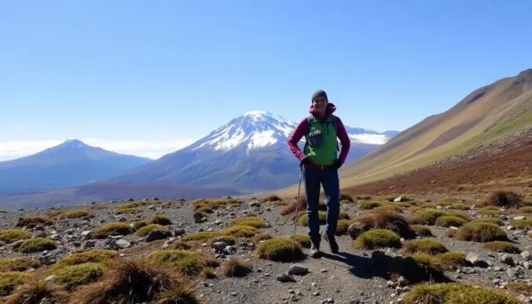
This hiking trail traverses an active volcanic zone, nestled between the towering peaks of Mount Tongariro (1,967 meters) and Mount Ngauruhoe (2,291 meters), famously known as "Mordor" in Peter Jackson's cinematic adaptation of J.R.R. Tolkien's "The Lord of the Rings." The stark beauty of this terrain, marked by craters, emerald lakes, and rugged landscapes, captivates all who venture here.
Step-by-step trekking guide
To give you a better idea of what to expect, here's a breakdown of the trek, highlighting different segments and their level of difficulty:
From Mangatepopo Carpark (1,150 m) to Soda Spring (1,400 m)
- Difficulty level: Easy.
- Distance: 4.4 km. Estimated time: 1 hour and 30 minutes.
This section is a gentle ascent, featuring a mix of dirt paths and wooden boardwalks. As you walk alongside a stream, you'll encounter beautiful plains dotted with volcanic rocks while gradually making your way closer to Mordor.
From Soda Spring (1,400 m) to Ngauruhoe Crossing (1,660 m)
- Difficulty level: Challenging.
- Distance: 6.4 km. Estimated time: 2 hours and 30 minutes.
Often referred to as the "Devil's Stairs," this segment involves a steep climb with well-maintained steps. Despite the elevation, it's manageable with breaks. At the summit, a path leads to the peak of Mount Ngauruhoe, which can be tackled in 2 to 3 hours (a challenge we opted to skip).
Flat area to South Crater and the beginning of a new incline (1,660 m)
- Difficulty level: Easy.
- Distance: Approximately 7 km. Estimated time: 3 hours.
This portion offers a flat stretch between two climbs, presenting stunning views. It was here that we encountered our first patches of snow, with relatively mild weather conditions.
From South Crater (1,660 m) to Red Crater (1,886 m)
- Difficulty level: Difficult.
- Distance: 8.1 km. Estimated time: 3 hours and 50 minutes.
The ascent to the Red Crater is the most strenuous section, characterized by a steep incline with loose gravel and scree. You'll need to use your hands to grip onto a chain in certain areas. The wind picks up, and temperatures drop as you near the top.
From Red Crater (1,886 m) to Blue Lake (1,780 m) via the Emerald Lakes
- Difficulty level: Moderate.
- Distance: Approximately 10 km. Estimated time: 5 hours and 20 minutes (including a break for lunch).
At the Red Crater, you'll find a path leading to the summit of Mount Tongariro (1,967 m), which takes about 1.5 hours. We passed on this opportunity. The descent to the Emerald Lakes involves a slippery 200-meter drop; many hikers, including us, found themselves sliding down! The views here are postcard-perfect, showcasing the vivid turquoise waters that have made this trek famous.
From Blue Lake (1,780 m) to Ketetahi Hut (1,454 m)
- Difficulty level: Moderate.
- Distance: 13 km. Estimated time: 6 hours and 15 minutes.
In this section, we faced challenges due to snow-covered paths. We had to proceed cautiously to avoid slipping off the trail. The weather also took a turn for the worse, with fog and humidity setting in.
Planning your Tongariro Alpine Crossing
Before you hit the trail, it's crucial to consider several factors:
Weather considerations
Stay informed about the weather forecast leading up to your trek. The weather in Tongariro National Park can be unpredictable, changing rapidly, especially in mountainous regions. It’s advisable to check conditions regularly.
Where to start your trek
Depending on your preference, you have various options for parking and shuttle services. You can park your car in nearby towns like Turangi or National Park and arrange transportation, which is safer but pricier. Alternatively, you can park at the Mangatepopo Parking Lot and complete the hike, returning to your vehicle at the Ketetahi lot. We chose to leave our vehicle at Ketetahi and took a shuttle to Mangatepopo to start our journey.
Many shuttle services operate in the area, with prices averaging NZ$35 per person. We opted for Mountain Shuttle, run by a friendly Māori man named Kerehana and his daughter. They are planning to open a secure parking area to alleviate theft concerns, which will be located 900 meters from Ketetahi. They also provide showers and the option to spend the night in your van for free if you book with them.
Website: tongarirocrossing.com
Contact: info@tongarirocrossing.com
Price: NZ$35, with a 15% discount for students, seniors, and groups.
What to pack
Your gear will vary based on the season. In winter, snow gear is essential, while summer hikers may get away with sturdy walking shoes. During our hike in mid-October, we encountered some snowy sections, which delayed our progress. Essential items include:
- Rain jacket
- Warm hat and gloves
- Sun protection (sunglasses and sunscreen)
- Comfortable hiking boots or shoes
- Layers for warmth, as the weather can be unpredictable
Food and hydration
Hydration is critical; aim for 1.5 liters of water per person. Snack-wise, pack energy bars, chocolate, nuts, and sandwiches—enough to keep you fueled but not overloaded, as you won't be camping for days!
→ For more detailed information, visit the official Tongariro Crossing website.
Have you tackled the Tongariro Alpine Crossing? What was your experience like?
| Save on your trip |
| Compare and find cheap flights here |
| Find accommodation at the best prices here |
| Book activities and tours in Spanish here |
| Get a 5% discount on your travel insurance with IATI here |
| Reserve airport transfers here |
| Learn how to withdraw money without fees here |
| Get a discount on your eSIM with code 'MOCHILEANDO' here |
| Rent a car with the best deals here |
| Compare prices for van rentals here |
| The best travel books and guides here |
| All our articles on New Zealand |


